| Browse by Categories |
|
 |
|
|
|
| |
|
Esker Riada |
| |
| |
|
|
|
|
The Esker Riada is a natural system of mounds consisting of
gravel and rocks which are believed to have been deposited
approximately 10,000 years ago, when an ice-age glacier
covering western Europe melted as a result of local climatic
warming.
The word "esker" seems to be an Anglicised version of the
Celtic word "eiscir" (meaning ridge), and it appears in
slightly different forms in several Irish placenames. For
example, the village name of Ahascragh (in East Galway) is a
corruption of the Celtic words "Áth Eascrach": and the name
suggests a place where there is a river crossing in the
vicinity of a number of ridges.
To the Celts (or Keltoi as the ancient Greeks called them),
the Esker Riada was know as "An Slí Mór": which means "The
Great Highway".
Much of the Esker Riada is flanked by bogland. It runs in an
east/west direction across Ireland (sometimes in the form of
parallel ridges), and it divides the island into two parts
which are roughly equal. For the very earliest people of
ancient Ireland, An Slí Mór was the country's most important
land based thoroughfare.
Ireland's largest river, the Shannon, provided the earliest
settlers in the area with an easy means of travelling north
and south; and by coincidence it happened to flow through a
gap in the Esker Riada which was right in the centre of the
country. Between them, the Esker Riada and the Shannon
formed a natural "crossroads" right in the heart of Ireland.
In a general sort of way the four main arteries of this
intersection led off in the directions north, south, east,
and west.
Mythological Celtic sun gods are said to have used the line
of the Esker Riada as the arena for their daily battles; and
the moment to moment outcome of their power struggles was
displayed in terms of light and shade all along the ridge.
Some evenings, these occasionally fearsome conflicts would
end in a blazing ball of blood-red crimson; and people would
watch in amazement as the raging battlefield sank slowly
into Galway Bay. By morning time, when it rose again at the
opposite end of the Esker Riada, the sun might still be
showing signs of the blood-letting which took place the
previous day.
Following a battle at Maynooth around the year 123 AD,
Ireland was politically divided into two parts (north and
south of the Esker Riada) known as "Leath Cuinn", and "Leath
Mogha": "Conn's Half" and "Mogha's Half".
Medieval Latin texts refer to this natural mound which
transverses Ireland as "Via Magna". Saints, the
dispossessed, scholars, beggars, Celtic royalty, wandering
poets, and armies (including the infamous Black & Tans who
are still remembered by a few in the New Inn area), are
amongst the many in Ireland's long and often troubled
history who have travelled the Esker Riada.
Around the year 548 AD, St. Ciarán founded the monastic
settlement of Clonmacnoise where the river Shannon and the
Esker Riada cross each other. Not surprisingly perhaps, this
strategically placed monastery quickly became a major
European centre of spirituality, learning, trade,
craftsmanship, and political influence. At least two Celtic
High Kings of Ireland are buried there. After almost 1500
years, Clonmacnoise (which is just 6 miles or so downstream
from the town of Athlone) continues to attract large numbers
of visitors each year. Though St. Ciarán himself died
shortly before his monastery at Clonmacnoise was complete,
the group of people he assembled there carried on working:
and (in effect) they eventually created what is possibly the
world's first and most influential Christian university. For
several centuries, including a lengthy period after the
Anglo Norman invasion in the 1100's, the area in and around
Clonmacnoise was ruled over by the Celtic "Mac Cochláin"
family: which has several Anglicised spelling variations
including, for example, the surnames Coglan, and Coughlan.
Hundreds of years before Clonmacnoise, many of the
pre-Christian travellers on the Esker Riada would have been
coming and going to places like Tara, and the Rath of
Feerwore (where the Turoe Stone originally stood). Earlier
still, they would have used it for trips to Newgrange -
which was built around 3,100 BC. Possibly as long as 2,000
years before Newgrange, the people who built the Cairn at
Alloon would have also walked or rode their horses along the
Esker Riada. The Cairn at Alloon (which is just 5 miles to
the north of New Inn village) could be in the region of
7,000 years old - making it one of the very oldest manmade
monuments in the world.
The village of New Inn in East Galway seems to have evolved
in a way which almost left it sitting right on top of the
Esker Riada ridge. Unfortunately, most of the New Inn
section of this historic natural monument is now missing.
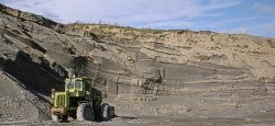
As a result of work which began in the mid 1950's, a 1.5
mile long section of the Esker Riada which ran through the
village of New Inn was removed by Galway County Council for
road building materials. Some of the photographs on page 2
provide an indication of what they left behind in its place. |
The Esker Riada is a natural system of mounds consisting of
gravel and rocks which are believed to have been deposited
approximately 10,000 years ago, when an ice-age glacier
covering western Europe melted as a result of local climatic
warming.
The word "esker" seems to be an Anglicised version of the
Celtic word "eiscir" (meaning ridge), and it appears in
slightly different forms in several Irish placenames. For
example, the village name of Ahascragh (in East Galway) is a
corruption of the Celtic words "Áth Eascrach": and the name
suggests a place where there is a river crossing in the
vicinity of a number of ridges.
To the Celts (or Keltoi as the ancient Greeks called them),
the Esker Riada was know as "An Slí Mór": which means "The
Great Highway".
Much of the Esker Riada is flanked by bogland. It runs in an
east/west direction across Ireland (sometimes in the form of
parallel ridges), and it divides the island into two parts
which are roughly equal. For the very earliest people of
ancient Ireland, An Slí Mór was the country's most important
land based thoroughfare.
Ireland's largest river, the Shannon, provided the earliest
settlers in the area with an easy means of travelling north
and south; and by coincidence it happened to flow through a
gap in the Esker Riada which was right in the centre of the
country. Between them, the Esker Riada and the Shannon
formed a natural "crossroads" right in the heart of Ireland.
In a general sort of way the four main arteries of this
intersection led off in the directions north, south, east,
and west.
Mythological Celtic sun gods are said to have used the line
of the Esker Riada as the arena for their daily battles; and
the moment to moment outcome of their power struggles was
displayed in terms of light and shade all along the ridge.
Some evenings, these occasionally fearsome conflicts would
end in a blazing ball of blood-red crimson; and people would
watch in amazement as the raging battlefield sank slowly
into Galway Bay. By morning time, when it rose again at the
opposite end of the Esker Riada, the sun might still be
showing signs of the blood-letting which took place the
previous day.
Following a battle at Maynooth around the year 123 AD,
Ireland was politically divided into two parts (north and
south of the Esker Riada) known as "Leath Cuinn", and "Leath
Mogha": "Conn's Half" and "Mogha's Half".
Medieval Latin texts refer to this natural mound which
transverses Ireland as "Via Magna". Saints, the
dispossessed, scholars, beggars, Celtic royalty, wandering
poets, and armies (including the infamous Black & Tans who
are still remembered by a few in the New Inn area), are
amongst the many in Ireland's long and often troubled
history who have travelled the Esker Riada.
Around the year 548 AD, St. Ciarán founded the monastic
settlement of Clonmacnoise where the river Shannon and the
Esker Riada cross each other. Not surprisingly perhaps, this
strategically placed monastery quickly became a major
European centre of spirituality, learning, trade,
craftsmanship, and political influence. At least two Celtic
High Kings of Ireland are buried there. After almost 1500
years, Clonmacnoise (which is just 6 miles or so downstream
from the town of Athlone) continues to attract large numbers
of visitors each year. Though St. Ciarán himself died
shortly before his monastery at Clonmacnoise was complete,
the group of people he assembled there carried on working:
and (in effect) they eventually created what is possibly the
world's first and most influential Christian university. For
several centuries, including a lengthy period after the
Anglo Norman invasion in the 1100's, the area in and around
Clonmacnoise was ruled over by the Celtic "Mac Cochláin"
family: which has several Anglicised spelling variations
including, for example, the surnames Coglan, and Coughlan.
Hundreds of years before Clonmacnoise, many of the
pre-Christian travellers on the Esker Riada would have been
coming and going to places like Tara, and the Rath of
Feerwore (where the Turoe Stone originally stood). Earlier
still, they would have used it for trips to Newgrange -
which was built around 3,100 BC. Possibly as long as 2,000
years before Newgrange, the people who built the Cairn at
Alloon would have also walked or rode their horses along the
Esker Riada. The Cairn at Alloon (which is just 5 miles to
the north of New Inn village) could be in the region of
7,000 years old - making it one of the very oldest manmade
monuments in the world.
The village of New Inn in East Galway seems to have evolved
in a way which almost left it sitting right on top of the
Esker Riada ridge. Unfortunately, most of the New Inn
section of this historic natural monument is now missing.
|
|
As a result of work which began in the mid 1950's, a 1.5
mile long section of the Esker Riada which ran through the
village of New Inn was removed by Galway County Council for
road building materials. Some of the photographs on page 2
provide an indication of what they left behind in its place. |
 |
|
|
|